Object ID:
1992.268
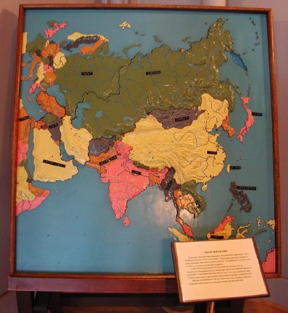
Title:
Europe & Asia Relief Map on Easel
Creator:
American Printing House for the Blind
Description:
Dissected Relief Map of Asia, partial Europe and Africa; molded epoxy on plywood, painted and dissected; oceans and other waters are blue, political divisions painted in pink, yellow, olive green, dark gray, and dull orange; capitol cities indicated by pointed red studs, other cities by rounded black studs; geographic features are in relief; boundaries on non-dissected areas of Europe and Africa indicated by raised dotted lines; DYMO tape braille labels; raised wooden frame; wooden easel; note that Sarawak and Sabah on Borneo are still independent nations (pre-1963), Korea is undivided (pre-1953), Germany is Undivided, (pre-1949), Pakistan and India are divided (post 1947), the Yemeni nations on the Arabian Peninsula are not shown (pre-1962), Israel is shown (post 1947).
Dimensions:
H-43.5 W-41.5 D-2.5 inches
Date:
ca. 1948
Made by:
American Printing House for the Blind
Place of Origin:
Louisville, KY
Collection:
APH Collection
Provenance:
APH Superintendent Benjamin Huntoon began making wooden relief maps in the basement of the Ky. School for the Blind in the 1870s. The 1876 APH annual report described dissected maps produced at APH in partnership with John P. Morton & Company of Louisville. By 1921, large continental dissected relief maps were available, with a shellac finish. Handcarved, painted wooden maps appeared in the 1870s. APH experimented with molded maps as early as the 1930s. This style map appeared in the 1950s and 60s. Initially, epoxy was poured into a mold and then a Masonite board was inserted. Later, as Masonite rose in price, plywood was substituted.
Credit Line:
Gift of the Missouri School for the Blind, 1992.268.
Click to Enlarge
 Dissected map of Asia
 Dissected map of Asia